Showing posts with label jean delauche. Show all posts

Saturday, November 3, 2018

SENJI FORT FROM THE DAYS OF JAIN SAINTS TO FALL TO FOREIGNERS BY TREASON


THE GINGEE FORT OF VALOUR

N.Nandhivarman

The silent revolution by French institutions in Pondicherry is not being noticed with requisite interest. Professor M.Bourdat of Lycee Francaise in his book 18 th Century Pondicherry published in 1992 writes about Inland Forts, but fortunately the task to write about Senji (Gingee) falls on the shoulders of Jean Deloche of the Ecole Francaise D’Extreme-Orient and he had produced a monumental work in his mother tongue French entitled “ Senji (Gingi) Ville fortifie’e du pays Tamoul”. By next year English version of this book is going to appear. Then it will take decades to see it in Tamil. To know about the history of a Fort situated in Tamil Nadu, more than the Universities and Research Institutions here the, French institute called Ecole Francaise D’Extreme Orient had been rendering valuable services, which must be lauded with deep sense of gratitude. The archeological excavations of Arikamedu brought out in a book by Vimala Begley and titled “ The Ancient Port of Arikamedu Vol I” is yet to be translated into Tamil. Now the French book on Senji by this institute must awaken Indian Research institutions to keep pace and bring both books in Tamil for the benefit of Tamil speaking people.

Far away from Pondicherry the entrance of the Gingee Fort has got a Pondicherry Gate. Similarly Pondicherry has a Gingee Salai, road that leads to Gingee. Why So? It denotes the inseparable historical connectivity between these two places. French captured Gingee and it remained with the French for almost a decade. The battle for Gingee is vividly portrayed in volume XV of the “ Lettres edifiantes et curieuses “ written by a Jesuit priest Father Lavaur. “ On September 11, 1750 Bussy and d’Auteuil arrived at the scene of battle towards 7 o’clock in the evening. While the besieged opened fire in un-coordinated fashion French artillery contained them within their cover. When the moon had set, a detachment under the command of three officers scaled the hill of Rajagiri. It is not known how these men were able to clear the deep breach with its drawbridge, which defended the topmost boulder, an enormous natural donjon. Then towards 4 o’ clock in the morning, a loud cry was heard coming from the top of one of the mountains. “ Vive Le Roll”. It was Mm de Saint Georges, Veri and Le Normand who, followed by their troops had carried out the order they had been given. The attack then became general. M d’ Fauteuil had the gate of the citadel blown up. Terror spread amongst the defending Moors who fired weekly several times and then fled. In less than an hour one had become master of all.” This how French conquest of Gingee is recorded.

Many have conquered and many have ruled   Gingee but a young man known for his bravery is still the hero of Gingee, that too after getting killed in a war. Yes, this brave man Desingh at the age of 22 with just 500 troopers and 350 horses faced an army of 8000 horsemen and 10,000 soldiers. The result he lost his life, his wife got immolated in his funeral pyre. But he lives in history and peoples memory. Raja Desingh, the film where MGRamachandiran played Raja Desingh was not well received by the audience because the fans of MGR did not relish the thought of hero dying in a war. But the real hero Raja Desingh is a hero living in folklore, ballads and peoples memory. The difference in these battles is while French recorded the history of the battle, Tamils wrote folk songs adding their imaginative skills, and that is why historians dismiss these literary evidences unless corroborated with archaeological and other findings. A question arises to every ones mind. How could a fort that produced the heroic Desingh in later days fall so easily to French?  The answer is found in a book of a French scholar who is true to his quest towards truth.

This impregnable fortress had fallen in alien hands and such defeats are made a post mortem by a French scholar Bourdot in his book “18 th Century Pondicherry.” “It was a revolt amongst the besieged that opened the gates to Bijapur’s army. It was an act of treason that enabled the Maharatta Shivaji to take possession of it in 1677. Without the help of corruption the place would never had fallen to the Moghul power twenty years later. Lastly it is doubtful whether Bussy with his 200 men would have been able to succeed in just few hours, with a raid that resulted in the surrender of the garrison, had it not been the panic and terror that could overcome the most courageous of the defenders during a night attack contrary to all rules especially that night was without moon or starts and when the assailants are yelling demoniacally in an unknown tongue”. M.Bourdat deserves due applauds for placing these truths in the pages of history to set the record straight.


 Jain Saints had dwelled in the hills of Gingee from 2-nd century to 6 th centuries, as evident by many stone carvings and other evidences of Gingee being citadel of Jainism. Gingee was under Pallava Emperors between 600 to 900 AD. Chozha Emperors ruled Gingee between 900 to 1103 AD. In the stone epigraphs at Aanangur of Athitya Chozhan (871-907) and of Athiya Chozhan II (985-1013) it becomes crystal clear that Chozha Emperors ruled Gingee. Pandya Emperors, Chozha Rulers and Hoysala Kings ruled between 1014 to 1190 AD. Yadhava kings ruled Gingee between 1190 to 1330 AD. It came under Vijayanagar rule from the fag end of 14 th century and for 150 years it was under Vijayanagar rule. It came under the rule of Bijapur Sultans between 1649-1677 AD. Maharastrians ruled from 1677-1697. Moghuls ruled from 1700-1750 AD. It slipped between British and French rule .from 1750. This is in nutshell the historical imprints left on Gingee, and for such a Fort which has a history dating back to 1800 years if proper publicity is made in abroad it will definitely attract world tourists. It also needs the help of world agencies that protect heritage to improve its infrastructure and other amenities. As an authority on Gingee Professor Jean Deloche describes with passion “ the technological skills shown in water management and also in the art of war after the invention of gunpowder.”


Professor Jean Deloche elaborates the military architecture angle too with vivid details. According to him, during the rule of Vijayanagar Governors “the construction was based on quadrangular works. Curtain walls were made of segments forming salient angles, flanqued by square or rectangular towers. Stonewalls were made of earth and rubble filling, with wedge shaped stone blocks and no mortar in joints except in battlement of stone or brick. Gateways consisted of two rectangular platforms separated by a central passageway. This is the old system of fortification.”

Talking to us enthusiastically the Professor is at his best spirit while he narrates about the profound changes brought by Nayaks in their almost 100 year rule “ in the art of defense, a consequence of the introduction of gun powder into warfare and the development of powerful artillery. It is based on circular and semi circular works, which by establishing a flanking fire, remedied the defects of former constructions. It started with the reshaping of some of the old walls and battlements. Embankments of earth were given a facing of masonry and towers were rounded in the lower fort, almond shaped merlons replaced the older ones”

“The big innovation of the period is the construction of the first enclosure, with semi circular towers, surrounding Krishnagiri and extending to the eastern cliff of Chandrayandurgam, linking the three hills, in the form of a triangle. With extensive use of explosive projectiles and the development of siege artillery, the other mountains Kurangudurgam and Kusumalai were also fortified in the same way, as well as the south west spur of Chandrayanmdurgam, since then called Sakkilidurgam”.

“A new defensive system was adopted to protect the gateways. Moreover cavaliers or round structures were raised behind the towers to lend support and provide firing platforms for artillery” This architectural marvel from military point of view and from the general view found expression in the best water management plan of a fort blended together had created a uniqueness and hence Jean Deloche describes that it

The Fort at Gingee declared as National Monument from 1921 is under the Archeological Department. Its history and the archeological finds in its vicinity must be publicized to promote archeological and historical tourism. French scholar Jean Deloche and his publications though are known to scholars must be taken to the common man and Government of India must suitably honour him. But no steps are afoot in governmental promotion of archeological and historical tourism. An Engineer by profession R.Mani had been tirelessly giving a helping hand in preparation of maps and repairs of forts including Gingee fort. He has also penned a book in Tamil “ Varalatril Gingee. This is just a candle while we have to illuminate Gingee’s history with 1000 lights.

Courtesy : NEW INDIAN EXPRESS 25.09.2004 

Friday, September 28, 2018

THE GINGEE FORT OF VALOUR


THE GINGEE FORT OF VALOUR

N.Nandhivarman

The silent revolution by French institutions in Pondicherry is not being noticed with requisite interest. Professor M.Bourdat of Lycee Francaise in his book 18 th Century Pondicherry published in 1992 writes about Inland Forts, but fortunately the task to write about Senji (Gingee) falls on the shoulders of Jean Deloche of the Ecole Francaise D’Extreme-Orient and he had produced a monumental work in his mother tongue French entitled “Senji (Gingi) Ville fortifie’e du pays Tamoul”. By next year English version of this book is going to appear. Then it will take decades to see it in Tamil. To know about the history of a Fort situated in Tamil Nadu, more than the Universities and Research Institutions here the, French institute called Ecole Francaise D’Extreme Orient had been rendering valuable services, which must be lauded with deep sense of gratitude. The archeological excavations of Arikamedu brought out in a book by Vimala Begley and titled “The Ancient Port of Arikamedu Vol I” is yet to be translated into Tamil. Now the French book on Senji by this institute must awaken Indian Research institutions to keep pace and bring both books in Tamil for the benefit of Tamil speaking people.

Far away from Pondicherry the entrance of the Gingee Fort has got a Pondicherry Gate. Similarly Pondicherry has a Gingee Salai, road that leads to Gingee. Why So? It denotes the inseparable historical connectivity between these two places. French captured Gingee and it remained with the French for almost a decade. The battle for Gingee is vividly portrayed in volume XV of the “Lettres edifiantes et curieuses “written by a Jesuit priest Father Lavaur. “ On September 11, 1750 Bussy and d’Auteuil arrived at the scene of battle towards 7 o’clock in the evening. While the besieged opened fire in un-coordinated fashion French artillery contained them within their cover. When the moon had set, a detachment under the command of three officers scaled the hill of Rajagiri.

It is not known how these men were able to clear the deep breach with its drawbridge, which defended the topmost boulder, an enormous natural donjon. Then towards 4 o’ clock in the morning, a loud cry was heard coming from the top of one of the mountains. “Vive Le Roll”. It was Mm de Saint Georges, Veri and Le Normandy who, followed by their troops had carried out the order they had been given. The attack then became general. M d’ Fauteuil had the gate of the citadel blown up.

Terror spread amongst the defending Moors who fired weekly several times and then fled. In less than an hour one had become master of all.” This how French conquest of Gingee is recorded.

Many have conquered and many have ruled   Gingee but a young man known for his bravery is still the hero of Gingee, that too after getting killed in a war. Yes, this brave man Desingh at the age of 22 with just 500 troopers and 350 horses faced an army of 8000 horsemen and 10,000 soldiers. The result he lost his life, his wife got immolated in his funeral pyre. But he lives in history and peoples memory. Raja Desingh, the film where MGRamachandiran played Raja Desingh was not well received by the audience because the fans of MGR did not relish the thought of hero dying in a war. But the real hero Raja Desingh is a hero living in folklore, ballads and peoples memory. The difference in these battles is while French recorded the history of the battle, Tamils wrote folk songs adding their imaginative skills, and that is why historians dismiss these literary evidences unless corroborated with archaeological and other findings. A question arises to every ones mind. How could a fort that produced the heroic Desingh in later days fall so easily to French?  The answer is found in a book of a French scholar who is true to his quest towards truth.

This impregnable fortress had fallen in alien hands and such defeats are made a post mortem by a French scholar Bourdot in his book “18 th Century Pondicherry.” “It was a revolt amongst the besieged that opened the gates to Bijapur’s army. It was an act of treason that enabled the Maharatta Shivaji to take possession of it in 1677.

Without the help of corruption the place would never had fallen to the Moghul power twenty years later. Lastly it is doubtful whether Bussy with his 200 men would have been able to succeed in just few hours, with a raid that resulted in the surrender of the garrison, had it not been the panic and terror that could overcome the most courageous of the defenders during a night attack contrary to all rules especially that night was without moon or starts and when the assailants are yelling demoniacally in an unknown tongue”. M.Bourdat deserves due applauds for placing these truths in the pages of history to set the record straight.

 Jain Saints had dwelled in the hills of Gingee from 2-nd century to 6 th centuries, as evident by many stone carvings and other evidences of Gingee being citadel of Jainism. Gingee was under Pallava Emperors between 600 to 900 AD. Chozha Emperors ruled Gingee between 900 to 1103 AD. In the stone epigraphs at Aanangur of Athitya Chozhan (871-907) and of Athiya Chozhan II (985-1013) it becomes crystal clear that Chozha Emperors ruled Gingee. Pandya Emperors, Chozha Rulers and Hoysala Kings ruled between 1014 to 1190 AD. Yadhava kings ruled Gingee between 1190 to 1330 AD. It came under Vijayanagar rule from the fag end of 14 th century and for 150 years it was under Vijayanagar rule. It came under the rule of Bijapur Sultans between 1649-1677 AD. Maharastrians ruled from 1677-1697. Moghuls ruled from 1700-1750 AD. It slipped between British and French rule .from 1750. This is in nutshell the historical imprints left on Gingee, and for such a Fort which has a history dating back to 1800 years if proper publicity is made in abroad it will definitely attract world tourists. It also needs the help of world agencies that protect heritage to improve its infrastructure and other amenities. As an authority on Gingee Professor Jean Deloche describes with passion “the technological skills shown in water management and also in the art of war after the invention of gunpowder.”

Professor Jean Deloche elaborates the military architecture angle too with vivid details. According to him, during the rule of Vijayanagar Governors “the construction was based on quadrangular works. Curtain walls were made of segments forming salient angles, flanqued by square or rectangular towers. Stonewalls were made of earth and rubble filling, with wedge shaped stone blocks and no mortar in joints except in battlement of stone or brick. Gateways consisted of two rectangular platforms separated by a central passageway. This is the old system of fortification.”

Talking to us enthusiastically the Professor is at his best spirit while he narrates about the profound changes brought by Nayaks in their almost 100 year rule “ in the art of defense, a consequence of the introduction of gun powder into warfare and the development of powerful artillery. It is based on circular and semi circular works, which by establishing a flanking fire, remedied the defects of former constructions. It started with the reshaping of some of the old walls and battlements. Embankments of earth were given a facing of masonry and towers were rounded in the lower fort, almond shaped merlons replaced the older ones”

“The big innovation of the period is the construction of the first enclosure, with semi circular towers, surrounding Krishnagiri and extending to the eastern cliff of Chandrayandurgam, linking the three hills, in the form of a triangle. With extensive use of explosive projectiles and the development of siege artillery, the other mountains Kurangudurgam and Kusumalai were also fortified in the same way, as well as the south west spur of Chandrayanmdurgam, since then called Sakkilidurgam”.

“A new defensive system was adopted to protect the gateways. Moreover cavaliers or round structures were raised behind the towers to lend support and provide firing platforms for artillery” This architectural marvel from military point of view and from the general view found expression in the best water management plan of a fort blended together had created a uniqueness and hence Jean Deloche describes that it

The Fort at Gingee declared as National Monument from 1921 is under the Archeological Department. Its history and the archeological finds in its vicinity must be publicized to promote archeological and historical tourism. French scholar Jean Deloche and his publications though are known to scholars must be taken to the common man and Government of India must suitably honour him. But no steps are afoot in governmental promotion of archeological and historical tourism. An Engineer by profession R.Mani had been tirelessly giving a helping hand in preparation of maps and repairs of forts including Gingee fort. He has also penned a book in Tamil “ Varaltaril Gingee. This is just a candle while we have to illuminate Gingee’s history with 1000 lights.

[Courtesy: New Indian Express dated: 25th September 2004]

Sunday, September 2, 2018

THE DUTCH RULE OF PONDICHERRY

HistoryShare This Page
Pondicherry: The Dutch Connections (1693-1699)
by N. NandhivarmanBookmark and Share
The French connection Pondicherry has is known to one and all but not its Dutch connections. On September 7,1693 Pondicherry fell into the hands of the Dutch and remained five and half years in their possession until March 1699. It is common knowledge that Pondicherry near the beach area after grand canal in the east is known as white town and the west of grand canal is called as black town. French are not responsible for this divide on racial lines. The Dutch wanted to carve out a white area exclusively for themselves. They wanted to relocate Indian people from the white town area. " It is also beyond doubt that in their project to relocate the Indian community in a separate area to the west of the establishment and keeping the old town on the seashore for themselves, the Dutch are also at the origin of the separation between Ville Noire i.e. white town and Ville Blanche i.e. black town " opines Professor Jean Deloche of the Institut Francaise de Pondicherry.

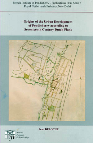
During that period Dutch tried to develop the Pondicherry into a great manufacturing center. By entering into an agreement with Raja Ram, the ruler of Senji, they enlarged the territory under their control. Then they planned a new town based on the grid pattern. Jacob Verbergmoes, the land surveyor worked out a great urban project for the Dutch.. "The Dutch did not alter the layout of the old town i.e. the fort area to the east of the marshy depression. They kept the rough fence bordering the northern and southern part. They did not modify the fort and its outer works; on the contrary they even repaired the breaches made in the walls and the damage done to the bastions. They did not demolish the Malabar church for the native Christians or the French storehouses and the godowns but they decided not to rebuild the blocks of stone houses to the East of the Fort which had been destroyed by Francois Martin during the siege. The streets therefore had the same alignments. On the Western side on the other hand they completely changed the structure of the town. First they seized the properties of the French company and the religious orders, particularly the gardens"

In fact, the Dutch plans of Pondicherry preserved at the National Archives at The Hague show that the orthogonal street pattern of the town is a creation of the Dutch. The plans of 1693 show that, in Francois Martin's time, the streets or lanes were following an irregular pattern, without any shape or symmetry, whereas in the plans drafted in 1694, during the Dutch occupation, one finds the design of a large new town, with a very regular geometric lay out, rectangular blocks of houses, separated by straight streets, intersecting at right angles. This great urban project of the Dutch company was adopted by the French who systematically carried out the extensive straightening out of streets into a planned grid, during the first half of the 18 th century" This is how Jean Deloche summarizes the contents of his book published in 2004 with 11 figures and 6 plates. " Origins of the Urban Development of Pondicherry according to 17 th Century Dutch Plans" is a masterpiece placing truth in its right place. People must appreciate the French Institution here and the French author who did not falter in placing truth above all.

The Dutch evidences had thrown more light on the History of Pondicherry's Urban Development. The Plan of the fortress and town "Poedechery" as it is currently being built on 20 th November 1694, available with Dutch Museum not only gives authentic version of the scene of those days but also spells Pudhucherri, the correct Tamil name instead of the corrupted version of Pondicherry.

In his book "City Planning and Architecture in Pondicherry " P. Richard thinks that the French adapted "their plan to the natural conditions of the littoral. This was possible because of the straight coast line was a very strong feature of the site and has from the beginning, determined the general orientation of the buildings and the direction of the streets, behind the dune, the low marshy lands and their outlet, running parallel to the seashore, increased this trend."

Ron van Oers is of the opinion that Dutch colonial settlements were built on a "Strict geometrical design to subdivide the usable area into building plots. All had a common image of being neat and well organized." On the orthogonal street model applied in Pondicherry he says "Dutch preferred this pattern since it was symbolic of an ordered, well managed society, hierarchical but democratic, it was emblematic for the hard working god fearing Dutch Calvinists".

"French appropriated this great design and that the extensive straightening out of the streets into a planned grid, systematically carried out by their governors in the first half of the 18th century, was therefore the extension of the existing Dutch orthogonal pattern into the rest of the town." Says Historian Jean Deloche who lives in Pondicherry. A great scholar who loves Tamil lives here unknown to fellow Tamils and he humbly refuses to get photographed because he wants his works to speak for ages to come. 

Share This:
11-May-2008
More by :  N. Nandhivarman
Views: 2507      Comments: 1

Comments on this Article


CommentI am at least 7 years late in commenting on this blog post. I am glad I stumbled on this to learn that for a very brief period Dutch controlled Pondichery and called it correctly by the local name Pudhucherri. Thanks to Nandhivarman.

A correction in the article may be in order. It is stated that "The Dutch wanted to carve out a white area exclusively for themselves."and "the Dutch are also at the origin of the separation between Ville Noire i.e. white town and Ville Blanche i.e. black town " opines Professor Jean Deloche of the Institut Francaise de Pondicherry."

I think Prof. Jean Deloche is misquoted here, for Ville Noire means black town and not white town as mentioned above. Also Blanche (Blank) stands for no color or white. All wine drinkers know this! Thus Ville Blanche would be the white town.

The blog count says 2054 people read this article but nobody seemed to have noticed this error. May be it is time to keep the record straight. Cheers!

p. Rao
09/17/2015 00:38 AM

Saturday, August 2, 2014

DUTCH DESIGNED PONDICHERRY STREETS


 WE SPOILED PONDICHERRY’S URBAN DEVELOPMENT


N.Nandhivarman

If you go to Old Delhi you will be shocked by its irregular street pattern but in New Delhi you will appreciate the concept of planned city. In old Pondicherry you can see straight roads but in the suburban areas in post independence era all that symmetry of streets is lost. How could such a legacy be thrown to winds? There is a saying in Pondicherry. In Tamil they say “Veethi Azhagu undu, Neethi Azhagu illai”. Veethi Azhagu means beauty of the streets. Who were the people who laid down the blueprint for straight streets in Pondicherry? Some may think it is local people. Some believe it is French. “ No, it is the work of the Dutch, “ says Jean Deloche, Historian based at the Ecole Francaise d”Extreme Orient at Pondicherry.

“ Some Indian scholars consider that the town was built according to the principles of the ancient Hindu treatises or architecture, particularly the Shilpa Sastra. French historians, on the other hand, feel that the plan should be considered as an achievement of French mind. In fact, the Dutch plans of Pondicherry preserved at the National Archives at The Hague show that the orthogonal street pattern of the town is a creation of the Dutch. The plans of 1693 show that, in Francois Martin’s time, the streets or lanes were following an irregular pattern, without any shape or symmetry, whereas in the plans drafted in 1694, during the Dutch occupation, one finds the design of a large new town, with a very regular geometric lay out, rectangular blocks of houses, separated by straight streets, intersecting at right angles. This great urban project of the Dutch company was adopted by the French who systematically carried out the extensive straightening out of streets into a planned grid, during the first half of the 18 th century” This is how Jean Deloche summarizes the contents of his book published in 2004 with 11 figures and 6 plates. “ Origins of the Urban Development of Pondicherry according to 17 th Century Dutch Plans” is a masterpiece placing truth in its right place. People must appreciate the French Institution here and the French author who did not falter in placing truth above all.

How did Pondicherry look like in 1700 A.D. “ Like an active hive developing its honeycomb, the town extended in a grid pattern along the left bank of the coastal river Uppar, to the north west of its citadel which was still no more than a small rectangular fort, Fort Barlong” This is how Professor M.Bourdart of the Lysee Francaise narrates in his book “18 th century Pondicherry “published in 1992. There is another map engraved as “ Map of Pondicherry” published by Nicholas de Fer in Paris in the year 1705. There is another plan of Pondicherry of 1741, which depicts Pondicherry, a year before the arrival of Dupliex. “ On this excellent plan are already shown the principal monuments of the town which was riveted to the Indian soil by the star shaped bolt of its fort, Fort Louis. The town’s appearance was to alter but little with time, at least as regards its outer contours. The fortifications would be leveled and would give place to the boulevards that today encircle the town.”

Well there are other evidences of that hoary past. One is the watercolor map of 1750 and the other is drawing of. Le Gentil who authored “Voyage dans les mers de l’inde, and visited Pondicherry twice in 1761 and 1769.

The Dutch evidences had thrown more light on the History of Pondicherry’s Urban Development. The Plan of the fortress and town “Poedechery” as it is currently being built on 20 th November 1694, available with Dutch Museum not only gives authentic version of the scene of those days but also spells Pudhucherri, the correct Tamil name instead of the corrupted version of Pondicherry.

In his book “City Planning and Architecture in Pondicherry “ P.Pichard thinks that the French adapted “their plan to the natural conditions of the littoral. This was possible because of the straight coast line was a very strong feature of the site and has from the beginning, determined the general orientation of the buildings and the direction of the streets, behind the dune, the low marshy lands and their outlet, running parallel to the seashore, increased this trend.”

Ron van Oers is of the opinion that Dutch colonial settlements were built on a “Strict geometrical design to subdivide the usable area into building plots. All had a common image of being neat and well organized.” On the orthogonal street model applied in Pondicherry he says Dutch preferred this pattern since” it was symbolic of an ordered, well managed society, hierarchical but democratic, it was emblematic for the hard working god fearing Dutch Calvinists”

“French appropriated this great design and that the extensive straightening out of the streets into a planned grid, systematically carried out by their governors in the first half of the 18 th century, was therefore the extension of the existing Dutch orthogonal pattern into the rest of the town.”  Says Historian Jean Deloche who lives in Pondicherry  A great scholar who loves Tamil lives here unknown to fellow Tamils and he humbly refuses to get photographed because he wants his works to speak for ages to come. The billion  dollar question is “If French could appropriate whatever good plans of the Dutch and beautify Pondicherry, who misled and buried such a planned legacy in the post independence era while sub urban colonies mushroomed here?” Let soul search begin.


1.     1700jpg: Pondicherry in the year 1700
2.     1705jpg : Map of Pondicherry by Nicholas de Fer in Paris (1705)
3.     Dupliex jpg: Pondicherry before the arrival of Dupliex
4.     Waterjpg:Watercolour picture of Pondicherry 1750

5.     Drawing.jpg :Le Gentil’s Drawings